File:ElectoralCollege2000-Large.png
Jump to navigation
Jump to search

Size of this preview: 800 × 430 pixels. Other resolution: 1,182 × 635 pixels.
Original file (1,182 × 635 pixels, file size: 175 KB, MIME type: image/png)
| U.S. presidential election maps from the National Atlas of the United States |
| See also: SVG maps |
| 1789 · 1792 · 1796 · 1800 · 1804 · 1808 · 1812 · 1816 · 1820 · 1824 · 1828 · 1832 · 1836 · 1840 · 1844 · 1848 · 1852 · 1856 · 1860 · 1864 · 1868 · 1872 · 1876 · 1880 · 1884 · 1888 · 1892 · 1896 · 1900 · 1904 · 1908 · 1912 · 1916 · 1920 · 1924 · 1928 · 1932 · 1936 · 1940 · 1944 · 1948 · 1952 · 1956 · 1960 · 1964 · 1968 · 1972 · 1976 · 1980 · 1984 · 1988 · 1992 · 1996 · 2000 · 2004 |
Summary
| Description |
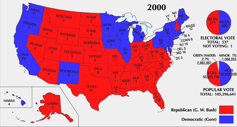
English: 2000 Electoral College Map |
|||
| Source | https://nationalmap.gov/small_scale/printable/elections.html | |||
| Author | United States Geological Survey | |||
| Other versions |
|


Licensing
This map was obtained from an edition of the National Atlas of the United States. Like almost all works of the U.S. federal government, works from the National Atlas are in the public domain in the United States.
Online access: NationalAtlas.gov | 1970 print edition: Library of Congress, Perry-Castañeda Library
|
File history
Click on a date/time to view the file as it appeared at that time.
| Date/Time | Thumbnail | Dimensions | User | Comment | |
|---|---|---|---|---|---|
| current | 18:51, 25 June 2008 | | 1,182 × 635 (175 KB) | imagescommonswiki>Tallicfan20 | better resolution |
File usage
The following file is a duplicate of this file (more details):
- File:ElectoralCollege2000-Large.png from Wikimedia Commons
There are no pages that use this file.