File:KhSh9colkey.png
Jump to navigation
Jump to search

Size of this preview: 624 × 600 pixels. Other resolution: 1,872 × 1,800 pixels.
Original file (1,872 × 1,800 pixels, file size: 2.99 MB, MIME type: image/png)
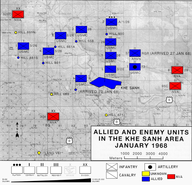
| Description | Map of area surrounding Khe Sanh during the Tet Offensive modified to include color and explanation of map symbols |
| Date | Original 1968 modified 02:36, 6 December 2007 (UTC) |
| Source | Original map sourced from Schulimson, Jack (1997) US Marines in Vietnam: 1968, Washington DC: Marine Corps History and Museums Division, p. 71 . |
| Author | USMC modified by Anynobody 02:36, 6 December 2007 (UTC) |
| Permission (Reusing this file) |
Public Domain |
| Other versions | w:Image:KhSh9.jpg |
This file is a work of a United States Marine or employee, taken or made as part of that person's official duties. As a work of the U.S. federal government, it is in the public domain.
|
 |
File history
Click on a date/time to view the file as it appeared at that time.
| Date/Time | Thumbnail | Dimensions | User | Comment | |
|---|---|---|---|---|---|
| current | 21:36, 5 December 2007 | | 1,872 × 1,800 (2.99 MB) | imagescommonswiki>Anynobody~commonswiki | {{Information |Description=Map of area surrounding Khe Sanh during the Tet Offensive modified to include color and explanation of map symbols |Source=USMC |Date=Original 1968 modified ~~~~~ |Author=[[w:USMC|US |
File usage
The following file is a duplicate of this file (more details):
- File:KhSh9colkey.png from Wikimedia Commons
There are no pages that use this file.