File:NOAA map of Scotch Bonnet Ridge.jpg
Jump to navigation
Jump to search

Size of this preview: 800 × 545 pixels. Other resolutions: 2,560 × 1,743 pixels | 3,096 × 2,108 pixels.
Original file (3,096 × 2,108 pixels, file size: 5.17 MB, MIME type: image/jpeg)
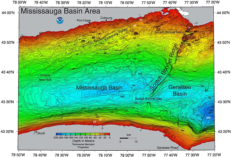
| Description | This NOAA map of Scotch Bonnet Ridge shows a central segment of Lake Ontario. | |||
| Source | https://ngdc.noaa.gov/mgg/greatlakes/lakeontario_cdrom/html/newnames.htm | |||
| Author | ||||
| Permission (Reusing this file) |
|
File history
Click on a date/time to view the file as it appeared at that time.
| Date/Time | Thumbnail | Dimensions | User | Comment | |
|---|---|---|---|---|---|
| current | 19:59, 22 June 2017 | | 3,096 × 2,108 (5.17 MB) | imagescommonswiki>Geo Swan | {{Information |Description=This {{w|NOAA}} map of {{w|Scotch Bonnet Ridge}} shows a central segment of {{w|Lake Ontario}}. |Source=https://ngdc.noaa.gov/mgg/greatlakes/lakeontario_cdrom/html/newnames.htm |Date= |Author= |Permission={{PD-USGov-NOAA}} |o... |
File usage
The following file is a duplicate of this file (more details):
- File:NOAA map of Scotch Bonnet Ridge.jpg from Wikimedia Commons
The following page uses this file: