Tombolo: Difference between revisions
Jump to navigation
Jump to search

Pat Palmer (talk | contribs) mNo edit summary |
Pat Palmer (talk | contribs) (adding another image) |
||
| Line 1: | Line 1: | ||
{{subpages}} | {{subpages}} | ||
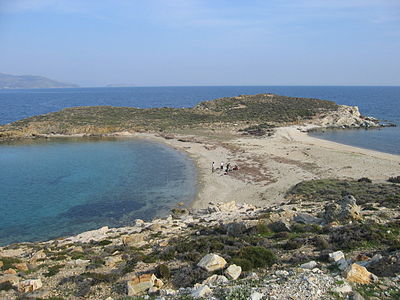
{{Image|Tombolo Paximadhi Eboea.jpg|right|400px|An example of a tombolo, seen from the air.}} | |||
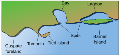
{{Image|Accreting coast Image6.svg|right|400px|Coastal and oceanic landforms. Cuspate foreland, tombolo, spit, bay, lagoon, barrier island.}} | |||
'''Tombolo''' is the geographic term for an [[isthmus]] formed when currents carrying sand are slowed by an island, depositing a sandbar that transforms the island into a [[peninsula]].<ref name=Mahiques/> [[Presqu'ile (Ontario)]] is an example of a tombolo. | '''Tombolo''' is the geographic term for an [[isthmus]] formed when currents carrying sand are slowed by an island, depositing a sandbar that transforms the island into a [[peninsula]].<ref name=Mahiques/> [[Presqu'ile (Ontario)]] is an example of a tombolo. | ||
Revision as of 07:14, 11 March 2024
Tombolo is the geographic term for an isthmus formed when currents carrying sand are slowed by an island, depositing a sandbar that transforms the island into a peninsula.[1] Presqu'ile (Ontario) is an example of a tombolo.
References
- ↑ Michel Michaelovitch De Mahiques (2016). “Tombolo”, Encyclopedia of Estuaries, 713–714. DOI:10.1007/978-94-017-8801-4_349. ISBN 978-94-017-8800-7.

