Ireland (island): Difference between revisions
imported>Jonathan N Chapple (re-word intro (Northern Ireland is not a sovereign state); add in U'Scots name) |
mNo edit summary |
||
| (3 intermediate revisions by 2 users not shown) | |||
| Line 1: | Line 1: | ||
{{subpages}} | {{subpages}} | ||
'''Ireland''' ([[Irish language|Irish]]: ''Éire''; [[Ulster-Scots language|Ulster-Scots]]: ''Airlann'') is an [[island]] lying off the north-west coast of [[Europe|Continental Europe]] with an area of 81,638 km².<ref>UN System-Wide Earthwatch Web Site, Islands by Land Area Available: http://islands.unep.ch/Tiarea.htm Accessed: 18th May, 2007.</ref> It is divided politically into the sovereign state of [[Ireland (state)|Ireland]] (described in its constitution as the Republic of Ireland, by which name it is also known), which occupies approximately five-sixths of the island, and the [[United Kingdom|British]] constituent country of [[Northern Ireland]], which occupies the remaining sixth in the north-east of the island. | '''Ireland''' ([[Irish language|Irish]]: ''Éire''; [[Ulster-Scots language|Ulster-Scots]]: ''Airlann'') is an [[island]] lying off the north-west coast of [[Europe|Continental Europe]] with an area of 81,638 km².<ref>UN System-Wide Earthwatch Web Site, Islands by Land Area Available: http://islands.unep.ch/Tiarea.htm Accessed: 18th May, 2007.</ref> It is divided politically into the sovereign state of [[Ireland (state)|Ireland]] (described in its constitution as the Republic of Ireland, by which name it is also known), which occupies approximately five-sixths of the island, and the [[United Kingdom|British]] constituent country of [[Northern Ireland]], which occupies the remaining sixth in the north-east of the island. | ||
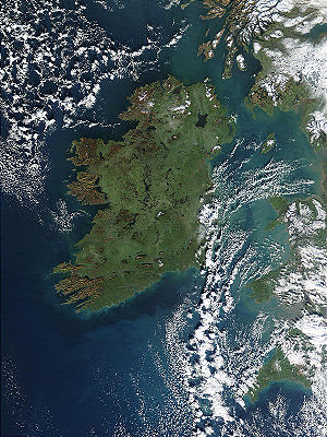
[[image:Ireland 1km.jpg|thumb|right||Satellite image of Ireland. The neighbouring island of [[Britain]] can be seen under cloud cover to the east.]] | [[image:Ireland 1km.jpg|thumb|right||Satellite image of Ireland. The neighbouring island of [[Britain]] can be seen under cloud cover to the east.]] | ||
| Line 13: | Line 12: | ||
===Notable features=== | ===Notable features=== | ||
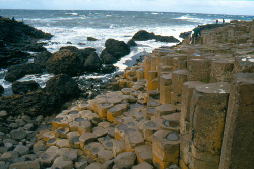
The coast of [[County Antrim]] features the spectacular [[Giant's Causeway]], which is formed from thousands of mostly hexagonal basalt columns, formed from [[Volcano|volcanic]] activity. The Giant's Causeway is a [[UNESCO]] [[World Heritage | The coast of [[County Antrim]] features the spectacular [[Giant's Causeway]], which is formed from thousands of mostly hexagonal basalt columns, formed from [[Volcano|volcanic]] activity. The Giant's Causeway is a [[UNESCO]] [[World Heritage site]]. | ||
[[Clew Bay]], in [[County Mayo]] features hundreds of islands, which are actually submerged [[drumlin|drumlins]]. | [[Clew Bay]], in [[County Mayo]] features hundreds of islands, which are actually submerged [[drumlin|drumlins]]. | ||
| Line 20: | Line 19: | ||
==Geology== | ==Geology== | ||
[[Image:Coasway.jpg|thumb|500px|right|The ''[[Giant's Causeway]]'' is a scenic outcrop of basaltic lava flows in | [[Image:Coasway.jpg|thumb|500px|right|The ''[[Giant's Causeway]]'' is a scenic outcrop of basaltic lava flows in northeastern Ireland.]] | ||
Recording and mapping of Ireland's bedrock geology began in the early 1800s. The first full geological map was produced in 1839, in preparation for the construction of Ireland's first railways. Work continued with the formation of the Geological Society of Ireland in 1845, and a one-inch scale (1:63,360) map of the whole island was completed in 1890.<ref>[http://www.gsi.ie/Education/Ancient+Maps Geological Survey Of Ireland: Ancient Maps] Accessed: 17th May, 2007.</ref> | Recording and mapping of Ireland's bedrock geology began in the early 1800s. The first full geological map was produced in 1839, in preparation for the construction of Ireland's first railways. Work continued with the formation of the Geological Society of Ireland in 1845, and a one-inch scale (1:63,360) map of the whole island was completed in 1890.<ref>[http://www.gsi.ie/Education/Ancient+Maps Geological Survey Of Ireland: Ancient Maps] Accessed: 17th May, 2007.</ref> | ||
| Line 35: | Line 34: | ||
==See also== | ==See also== | ||
* | *Ireland (disambiguation) | ||
*[[Ireland (state)|Ireland]] | *[[Ireland (state)|Ireland]] | ||
*[[Northern Ireland]] | *[[Northern Ireland]] | ||
*[[United Kingdom]] | *[[United Kingdom]] | ||
==References== | ==References== | ||
{{reflist}}[[Category:Suggestion Bot Tag]] | |||
Latest revision as of 16:01, 2 September 2024
Ireland (Irish: Éire; Ulster-Scots: Airlann) is an island lying off the north-west coast of Continental Europe with an area of 81,638 km².[1] It is divided politically into the sovereign state of Ireland (described in its constitution as the Republic of Ireland, by which name it is also known), which occupies approximately five-sixths of the island, and the British constituent country of Northern Ireland, which occupies the remaining sixth in the north-east of the island.

Subdivisions
Traditionally, the island of Ireland has been subdivided into four provinces and thirty-two counties. The provinces are: Leinster in the east, Munster in the south, Connacht in the west, and Ulster in the north. Of the thirty-two traditional counties, six (of nine Ulster counties) are within Northern Ireland, while the remaining twenty-six counties are in the Republic of Ireland. However, the traditional counties of Northern Ireland now only have ceremonial status, being replaced in 1974 by District Councils. Similarly, reform of local government in the Republic of Ireland has seen two counties further subdivided - Tipperary has been split into North and South Tipperary; and County Dublin has been split into the three new counties of Fingal, Dun Laoghaire-Rathdown and South Dublin. As five cities (Dublin, Cork, Galway, Limerick and Waterford) have independent council status, making them the equivalent of counties for local government purposes, this means that the Republic of Ireland now has thirty-four administrative areas.
However, despite these changes, the traditional thirty-two counties on the island still form an important part of heritage and local identity, and are still used in sporting and cultural contexts.
Geography
The coast of Ireland mostly consists of hills and low mountains (the highest point being Carrauntoohil at 1,041 m or 3,414 ft), with cliffs also being found on the west coast. The interior of the island is relatively flat land, traversed by rivers such as the River Shannon (the longest on the island, at 386 km) and several large lakes or loughs. The central plains of the island are part of the River Shannon watershed, containing large areas of bogland, used for peat extraction and production.
Notable features
The coast of County Antrim features the spectacular Giant's Causeway, which is formed from thousands of mostly hexagonal basalt columns, formed from volcanic activity. The Giant's Causeway is a UNESCO World Heritage site.
Clew Bay, in County Mayo features hundreds of islands, which are actually submerged drumlins.
The Burren, in County Clare is a bleak limestone karst region covering approximately 250 km2.
Geology

Recording and mapping of Ireland's bedrock geology began in the early 1800s. The first full geological map was produced in 1839, in preparation for the construction of Ireland's first railways. Work continued with the formation of the Geological Society of Ireland in 1845, and a one-inch scale (1:63,360) map of the whole island was completed in 1890.[2]
Most of the rocks of Ireland are relatively ancient (Paleozoic or older). In the north-west of the island (Counties Donegal and Londonderry), mostly metamorphic rocks such as schist, gneiss and quartzite are present. The north-east (Counties Antrim, Armagh and Down) is primarily basalt. The majority of the island's bedrock, however, is composed of limestones and sandstones of Paleozoic age.[3]
Climate
The local temperate climate is modified by the North Atlantic Current (or Gulf Stream) and is therefore relatively mild, enjoying fewer extremes than continental areas at similar latitudes. Summers are rarely very hot (temperatures only exceed 30ºC (86ºF) usually once every decade, though commonly reach 29ºC (84ºF) most summers. It freezes only occasionally in winter (temperatures below -6ºC (21ºF) are uncommon). Average annual temperature is about 9ºC. Precipitation is very common, with up to 275 days with rain in some parts of the country.
Flora and fauna
As a result of Ireland being split from mainland Europe sometime around the last Ice Age, the island lacks biodiversity. For example, there are only thirty-one species of mammal native to Ireland,[4] compared to sixty-six on Britain,[5] which lies closer to mainland Europe.
Similarly, only approximately nine hundred species of vascular plants (flowering plants, conifers and ferns) can be found, far smaller than the European average.[6][7]
See also
- Ireland (disambiguation)
- Ireland
- Northern Ireland
- United Kingdom
References
- ↑ UN System-Wide Earthwatch Web Site, Islands by Land Area Available: http://islands.unep.ch/Tiarea.htm Accessed: 18th May, 2007.
- ↑ Geological Survey Of Ireland: Ancient Maps Accessed: 17th May, 2007.
- ↑ Geological Society of Ireland, 2004: Map of the Bedrock Geology of Ireland Accessed: 17th May, 2007.
- ↑ EU Presidency 2004 website: Flora and Fauna of Ireland Accessed: 2nd June, 2007.
- ↑ People's Trust for Endangered Species | Mammals: about UK mammals 2nd June, 2007.
- ↑ Bergen.org: Project - Ireland Accessed: 13th June, 2007.
- ↑ David Webb: Journal of Life Sciences, Royal Dublin Society, 1983, pages 143-160: "The Flora of Ireland in its European Context" Accessed: 13th June, 2007