Scotch Bonnet Ridge: Difference between revisions
Jump to navigation
Jump to search

Pat Palmer (talk | contribs) mNo edit summary |
Pat Palmer (talk | contribs) mNo edit summary |
||
| (3 intermediate revisions by the same user not shown) | |||
| Line 1: | Line 1: | ||
{{subpages}} | {{subpages}} | ||
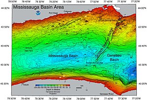
[[File:NOAA map of Scotch Bonnet Ridge.jpg | thumb]] | [[File:NOAA map of Scotch Bonnet Ridge.jpg | thumb]] | ||
'''Scotch Bonnet Ridge''' is a geologic ridge that crosses the [[Canada]]-[[United States of America|U.S.]] border | '''Scotch Bonnet Ridge''' is a geologic ridge that crosses the [[Canada]]-[[United States of America|U.S.]] border in [[Lake Ontario]], south of Prince Edward county in [[Ontario]].<ref name=ForWant/> [[Scotch Bonnet Island]] and [[Nicholson Island (Lake Ontario)|Nicholson Island]] lie off the shore of Prince Edward county. | ||
The ridge is composed of clay and till<ref name=BrTill>[https://www.britannica.com/science/till Till (geology)] in Britannica online.</ref> associated with glaciers and lakes.<ref name=CanadaEnv/> | The ridge is composed of clay and till<ref name=BrTill>[https://www.britannica.com/science/till Till (geology)] in Britannica online.</ref> associated with glaciers and lakes.<ref name=CanadaEnv/> | ||
| Line 34: | Line 34: | ||
</ref> | </ref> | ||
}} | }} | ||
Latest revision as of 12:20, 15 July 2024
Scotch Bonnet Ridge is a geologic ridge that crosses the Canada-U.S. border in Lake Ontario, south of Prince Edward county in Ontario.[1] Scotch Bonnet Island and Nicholson Island lie off the shore of Prince Edward county.
The ridge is composed of clay and till[2] associated with glaciers and lakes.[3]
References
- ↑ Marc Seguin. For Want of a Lighthouse: Building the Lighthouses of Eastern Lake Ontario 1828–1914, Trafford Publishing, 2015. Retrieved on 2017-06-22.
- ↑ Till (geology) in Britannica online.
- ↑ Scotch Bonnet Island and Mohawk Island National Wildlife Areas Management Plan. ISBN 978-1-100-22382-7. Retrieved on 2019-05-06. “The island is named after one of three north-south trending rises of glacio-lacustrine clay and till, known as the Scotch Bonnet Ridge, in eastern Lake Ontario.”
