Missouri River: Difference between revisions
Pat Palmer (talk | contribs) mNo edit summary |
Pat Palmer (talk | contribs) (adding some of the WP intro material) |
||
| Line 1: | Line 1: | ||
{{subpages}} | {{subpages}} | ||
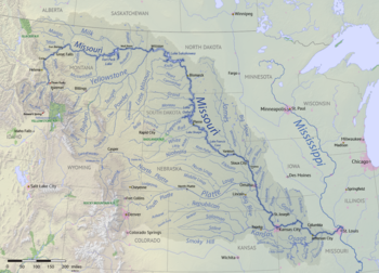
{{Image|Missouri River basin map.png|right|350px|The Missouri River system lies inland in the middle of the United States of America and forms the northeast state line for the state of [[Missouri]].}} | {{Image|Missouri River basin map.png|right|350px|The Missouri River system lies inland in the middle of the United States of America and forms the northeast state line for the state of [[Missouri]].}} | ||
The '''Missouri River''' is | The '''Missouri River''' is the longest [[river]] in the [[United States]].<ref name="RiversWorld">{{cite web |author=Howard Perlman, USGS |url=https://water.usgs.gov/edu/riversofworld.html |title=Lengths of major rivers |series=USGS Water-Science School |website=Ga.water.usgs.gov |date=October 31, 2012 |access-date=November 21, 2012 |archive-url=https://web.archive.org/web/20140309100631/http://water.usgs.gov/edu/riversofworld.html |archive-date=March 9, 2014 |url-status=dead }}</ref> It runs through the north central [[United States of America|U.S.]], draining from [[Montana]] 2315 miles to the [[Mississippi River]] north of [[St. Louis, Missouri|St. Louis]]. | ||
The Missouri River drains a sparsely populated, [[Semi-arid climate|semi-arid]] [[Drainage basin|watershed]] of more than 500,000 square miles (1,300,000 km<sup>2</sup>), which includes parts of ten U.S. states and two Canadian provinces. Although a tributary of the Mississippi, the Missouri River is slightly longer<ref name="USGS"/> and carries a comparable volume of water.<ref name="missouriflow"/><ref name="MississippiStLouis"/> When combined with the lower Mississippi River, it forms the [[List of rivers by length|world's fourth longest river system]].<ref name="RiversWorld" /> The river was one of the main routes for the westward expansion of the United States during the 19th century. The growth of the [[North American fur trade|fur trade]] in the early 19th century laid much of the groundwork as trappers explored the region and blazed trails. [[American pioneer|Pioneer]]s headed west ''en masse'' beginning in the 1830s, first by [[covered wagon]], then by the growing numbers of [[steamboat]]s that entered service on the river. Conflict between settlers and Native Americans in the watershed led to some of the most longstanding and violent of the [[American Indian Wars#Great Plains|American Indian Wars]]. | |||
During the 20th century, the Missouri River basin was developed extensively for irrigation, flood control, and the generation of [[hydroelectricity|hydroelectric power]]. Fifteen dams impound the [[main stem]] of the river, with hundreds more on tributaries. [[Meander]]s have been cut off and the river "channelized" (re-routed) to improve navigation, reducing its length by almost {{convert|200|mi|km}} from pre-development times. Although the lower [[Missouri River Valley|Missouri valley]] is now a populous and highly productive agricultural and industrial region, heavy development has taken its toll on wildlife and fish populations as well as water quality. | |||
Revision as of 05:18, 5 July 2023

The Missouri River is the longest river in the United States.[1] It runs through the north central U.S., draining from Montana 2315 miles to the Mississippi River north of St. Louis.
The Missouri River drains a sparsely populated, semi-arid watershed of more than 500,000 square miles (1,300,000 km2), which includes parts of ten U.S. states and two Canadian provinces. Although a tributary of the Mississippi, the Missouri River is slightly longer[2] and carries a comparable volume of water.[3][4] When combined with the lower Mississippi River, it forms the world's fourth longest river system.[1] The river was one of the main routes for the westward expansion of the United States during the 19th century. The growth of the fur trade in the early 19th century laid much of the groundwork as trappers explored the region and blazed trails. Pioneers headed west en masse beginning in the 1830s, first by covered wagon, then by the growing numbers of steamboats that entered service on the river. Conflict between settlers and Native Americans in the watershed led to some of the most longstanding and violent of the American Indian Wars.
During the 20th century, the Missouri River basin was developed extensively for irrigation, flood control, and the generation of hydroelectric power. Fifteen dams impound the main stem of the river, with hundreds more on tributaries. Meanders have been cut off and the river "channelized" (re-routed) to improve navigation, reducing its length by almost 200 mi (321.87 km) from pre-development times. Although the lower Missouri valley is now a populous and highly productive agricultural and industrial region, heavy development has taken its toll on wildlife and fish populations as well as water quality.
- ↑ Jump up to: 1.0 1.1 Howard Perlman, USGS (October 31, 2012). Lengths of major rivers.
- ↑ Cite error: Invalid
<ref>tag; no text was provided for refs namedUSGS - ↑ Cite error: Invalid
<ref>tag; no text was provided for refs namedmissouriflow - ↑ Cite error: Invalid
<ref>tag; no text was provided for refs namedMississippiStLouis