Nebraska (U.S. state): Difference between revisions
imported>James F. Perry (add shaded relief map) |
(land and water) |
||
| Line 9: | Line 9: | ||
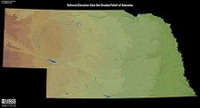
{{Image|Nebraska.jpg|right|225px|USGS shaded relief map of Nebraska}} | {{Image|Nebraska.jpg|right|225px|USGS shaded relief map of Nebraska}} | ||
Nebraska straddles two major physiographic zones. The eastern third of the state lies in the [[Central Lowland]] of the United States while the rest of the state lies in the [[Great Plains]]. Overall, much of the state is a gently sloping, rolling prairie, gaining elevation from east to west with some flatland, particularly the [[Sand Hills]], a vast, treeless, grassland in the north central and northwest portion of the state. | |||
== | ==Hydrosphere (rivers and drainage)== | ||
Nebraska is part of the [[Missouri River]] drainage system with rivers running from west to east following the general downhill slope of state. The major tributaries are the [[Platte River]] which runs through the center of the state and is vital to the state's irrigation system, the Niobrara River to the north and the Republican River to the south. | |||
=== | The entire area is underlain by the [[High Plains Aquifer]], a vast supply of groundwater which extends to several other states in the western United States. | ||
==Climate== | |||
==Economy== | |||
== History == | == History == | ||
Revision as of 11:01, 13 November 2022
Nebraska is a great plains state in the central United States of America. The name is derived from a Native American word meaning "flat water", referring to the Platte River, which flows across the state.
Known as the Cornhusker State, Nebraska is a major producer of agricultural products. The state bird is the Western Meadowlark, and the state flower the goldenrod.
Land
Physiography (land forms)
Nebraska straddles two major physiographic zones. The eastern third of the state lies in the Central Lowland of the United States while the rest of the state lies in the Great Plains. Overall, much of the state is a gently sloping, rolling prairie, gaining elevation from east to west with some flatland, particularly the Sand Hills, a vast, treeless, grassland in the north central and northwest portion of the state.
Hydrosphere (rivers and drainage)
Nebraska is part of the Missouri River drainage system with rivers running from west to east following the general downhill slope of state. The major tributaries are the Platte River which runs through the center of the state and is vital to the state's irrigation system, the Niobrara River to the north and the Republican River to the south.
The entire area is underlain by the High Plains Aquifer, a vast supply of groundwater which extends to several other states in the western United States.
Climate
Economy
History
Nebraska became a U.S. territory in 1854, with the seat of territorial government in Omaha. Nebraska became the 37th state to join the USA on March 1, 1867, when President Andrew Johnson signed its statehood bill. With statehood came a new capital, Lincoln, a tiny village formerly called Lancaster and renamed after the recently assassinated president.
The first state capitol building was completed in December 1868 just in time for the 1869 legislative session to be held in the new building.

