Garrison Creek (Ontario): Difference between revisions
Jump to navigation
Jump to search
George Swan (talk | contribs) (first draft here) |
George Swan (talk | contribs) (add image) |
||
| Line 1: | Line 1: | ||
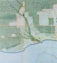
[[image:Lower course of Garrison Creek, 1818.jpg | thumb | Lower course of Garrison Creek, circa 1818.]] | |||
'''Garrison Creek''' was a short creek about 6 kilometres long, that flowed southeast | '''Garrison Creek''' was a short creek about 6 kilometres long, that flowed southeast | ||
into the west side of [[Toronto Harbour]]. It has been largely covered over and filled in, but geographical traces of the creek can still be found. The natural ampitheatre known as [[Christie Pits]] is one such remnant, the south end of [[Trinity Bellwoods Park]] is another. The name ''"Garrison Creek"'' was used because [[Fort York]] was built near the creek mouth. | into the west side of [[Toronto Harbour]]. It has been largely covered over and filled in, but geographical traces of the creek can still be found. The natural ampitheatre known as [[Christie Pits]] is one such remnant, the south end of [[Trinity Bellwoods Park]] is another. The name ''"Garrison Creek"'' was used because [[Fort York]] was built near the creek mouth. | ||
Volunteers lead popular tours of the course of the old watershed. | Volunteers lead popular tours of the course of the old watershed. | ||
Revision as of 06:51, 27 December 2023
Garrison Creek was a short creek about 6 kilometres long, that flowed southeast into the west side of Toronto Harbour. It has been largely covered over and filled in, but geographical traces of the creek can still be found. The natural ampitheatre known as Christie Pits is one such remnant, the south end of Trinity Bellwoods Park is another. The name "Garrison Creek" was used because Fort York was built near the creek mouth.
Volunteers lead popular tours of the course of the old watershed.
