Moss Park (Toronto): Difference between revisions
Pat Palmer (talk | contribs) (fixing link to Queen St) |
Pat Palmer (talk | contribs) mNo edit summary |
||
| Line 1: | Line 1: | ||
{{subpages}} | {{subpages}} | ||
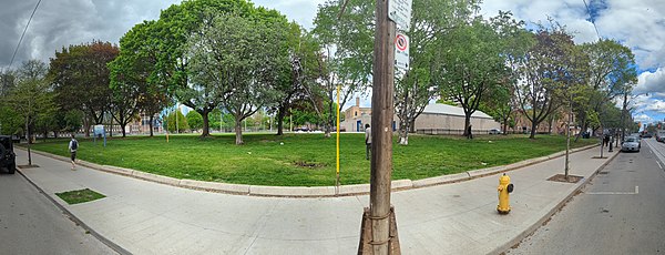
[[File:Moss Park, north side of Queen Street East, between Church and Jarvis, 2022 05 17 (52080921163) (cropped).jpg | thumb | 600px | The large mature trees lining the southern boundary of Moss Park will all have to be removed during the construction of [[Moss Park Station]].]] | [[File:Moss Park, north side of Queen Street East, between Church and Jarvis, 2022 05 17 (52080921163) (cropped).jpg | thumb | 600px | The large mature trees lining the southern boundary of Moss Park will all have to be removed during the construction of [[Moss Park Station]].]] | ||
'''Moss Park''' is the name of both a park | '''Moss Park''' is the name of both a park and a neighbourhood in Toronto<ref>[https://www.google.com/maps/place/Moss+Park,+Toronto,+ON,+Canada/@43.6543249,-79.3732581,1921m/data=!3m1!1e3!4m5!3m4!1s0x89d4cb3fc8847bf3:0x75efd76c989a077e!8m2!3d43.6547889!4d-79.3726025 Neighborhood and park] shown in Google Maps online.</ref>. | ||
The [[Canadian Armed Forces]] base known as the [[Moss Park Armoury]] sits adjacent to the park's western boundary.<ref name=blogto2019-02-03/> The [[Neil Innis Community Centre]] sits on its eastern edge. It is bounded by [[Shuter Street, Toronto|Shuter]] and [[Queen Street (Toronto)|Queen]] streets, on its north and south. | The [[Canadian Armed Forces]] base known as the [[Moss Park Armoury]] sits adjacent to the park's western boundary.<ref name=blogto2019-02-03/> The [[Neil Innis Community Centre]] sits on its eastern edge. It is bounded by [[Shuter Street, Toronto|Shuter]] and [[Queen Street (Toronto)|Queen]] streets, on its north and south. | ||
Revision as of 11:45, 11 May 2024

Moss Park is the name of both a park and a neighbourhood in Toronto[1]. The Canadian Armed Forces base known as the Moss Park Armoury sits adjacent to the park's western boundary.[2] The Neil Innis Community Centre sits on its eastern edge. It is bounded by Shuter and Queen streets, on its north and south.
In 2017 volunteers opened Toronto's first harm reduction site in Moss Park - without official sanction.[2] Addicts could go to the site, for free clean needles, and were allowed to administer illegal street drugs, within the site, so medical care could be administered if they should overdose.
The area around the park had long been considered one of the least desirable, by real estate developers, due to the large population of homeless individuals.[2] However, following the announcement that a subway station on the new Ontario Line would be built in the park, many nearby properties are being redeveloped.
References
- ↑ Neighborhood and park shown in Google Maps online.
- ↑ 2.0 2.1 2.2 Tanya Mok. Moss Park is the last overlooked neighbourhood in downtown Toronto, Blog TO, 2019-02-03. Retrieved on 2022-05-18. “It wasn’t always like this: according to some longtime residents, the area has degraded noticeably over the past decade. The increase of drug litter, open drug use, and more recently, the introduction of deadly bootleg fentanyl in street heroin, sparked the creation of the unsanctioned Moss Park Overdose Prevention Site (OPS) in 2017.”