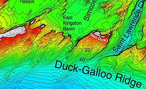
Information for "File:NOAA map of Duck Galloo Ridge (cropped) showing Timber, Swetman, Main Duck and Yorkshire islands, and some subsurface shoals.jpg"
Jump to navigation
Jump to search
View the protection log for this page.
Basic information
| Display title | File:NOAA map of Duck Galloo Ridge (cropped) showing Timber, Swetman, Main Duck and Yorkshire islands, and some subsurface shoals.jpg |
| Redirects to | File:NOAA map of Duck Galloo Ridge (cropped) showing Timber, Swetman, Main Duck and Yorkshire islands, and some subsurface shoals.jpg (info) |
| Default sort key | NOAA map of Duck Galloo Ridge (cropped) showing Timber, Swetman, Main Duck and Yorkshire islands, and some subsurface shoals.jpg |
| Page length (in bytes) | 0 |
| Namespace | File |
| Page ID | 0 |
| Page content language | en - English |
| Page content model | wikitext |
| Indexing by robots | Disallowed |
| Number of redirects to this page | 0 |
| Hash value | 37318448689e57e6552c1aea16496f585e27417a |
| Page image |  |
Page protection
| Create | Allow all users (infinite) |
| Upload | Allow all users |