File:San Diego Bay 1603.gif: Difference between revisions
Jump to navigation
Jump to search
imported>Robert A. Estremo ({{Image_Details|pd |description = Map showing San Diego Bay, made in Spain in 1603 from charts drawn by Vizcaíno's cartographer. |author = Sebastián Vizcaíno Expedition |source = http://www.sandiegohistory.org/journal/78winter/images/p8...) |
(== Summary == Importing file) Tag: Server-side upload |
||
| Line 1: | Line 1: | ||
== Summary == | == Summary == | ||
Importing file | |||
Latest revision as of 19:52, 11 March 2022
Summary
Importing file
File history
Click on a date/time to view the file as it appeared at that time.
| Date/Time | Thumbnail | Dimensions | User | Comment | |
|---|---|---|---|---|---|
| current | 19:52, 11 March 2022 | 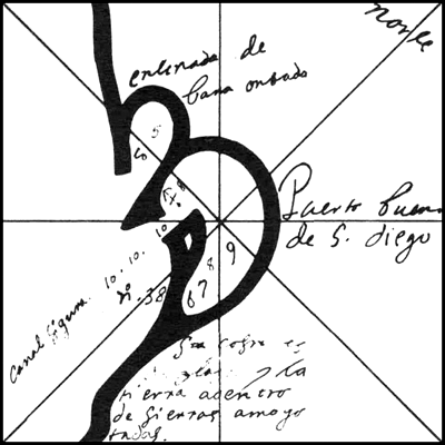 | 400 × 400 (39 KB) | Maintenance script (talk | contribs) | == Summary == Importing file |
You cannot overwrite this file.
File usage
The following page uses this file: