Small's Creek (Ontario): Difference between revisions
George Swan (talk | contribs) (first draft here) |
George Swan (talk | contribs) (trim metadata incompatible with this site) |
||
| Line 1: | Line 1: | ||
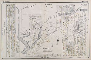
[[File:Smalls-Pond-Goads-Map.jpg | thumb | Smalls Creek flowed into [[Smalls Pond]].]] | |||
| | |||
'''Small's Creek''' was one of the three watercourses that flowed into [[Small's Pond]], a small body of water of several acres in area, located near the intersection of [[Queen Street, Toronto|Queen Street]] and [[Kingston Road (Toronto)|Kingston Road]], in [[Toronto, Ontario]].<ref name=VanishingPoint/> There is a small plain between the shore of [[Lake Ontario]] and the bluffs which marked the shore of the larger [[Glacial Lake Iroquois]], Bedrock was shallow on the plain. Smalls Creek, [[Tomlin's Creek]], the other watercourse that drains into Smalls Pond, and [[Ashbridge's Creek]] to the east were all small, short watercourses, with their headwaters on that small plain, had each become polluted by the turn of the 20th century, when the regions they flowed through were annexed into the growing city of [[Toronto]]. | '''Small's Creek''' was one of the three watercourses that flowed into [[Small's Pond]], a small body of water of several acres in area, located near the intersection of [[Queen Street, Toronto|Queen Street]] and [[Kingston Road (Toronto)|Kingston Road]], in [[Toronto, Ontario]].<ref name=VanishingPoint/> There is a small plain between the shore of [[Lake Ontario]] and the bluffs which marked the shore of the larger [[Glacial Lake Iroquois]], Bedrock was shallow on the plain. Smalls Creek, [[Tomlin's Creek]], the other watercourse that drains into Smalls Pond, and [[Ashbridge's Creek]] to the east were all small, short watercourses, with their headwaters on that small plain, had each become polluted by the turn of the 20th century, when the regions they flowed through were annexed into the growing city of [[Toronto]]. | ||
| Line 75: | Line 19: | ||
}} | }} | ||
</ref> | </ref> | ||
<ref name=BeachesLivingSmall> | <ref name=BeachesLivingSmall> | ||
{{cite news | {{cite news | ||
| Line 84: | Line 29: | ||
}} | }} | ||
</ref> | </ref> | ||
<ref name=VanishingPoint> | <ref name=VanishingPoint> | ||
{{cite web | {{cite web | ||
| Line 96: | Line 42: | ||
</ref> | </ref> | ||
}} | }} | ||
Revision as of 23:36, 30 January 2024

Small's Creek was one of the three watercourses that flowed into Small's Pond, a small body of water of several acres in area, located near the intersection of Queen Street and Kingston Road, in Toronto, Ontario.[1] There is a small plain between the shore of Lake Ontario and the bluffs which marked the shore of the larger Glacial Lake Iroquois, Bedrock was shallow on the plain. Smalls Creek, Tomlin's Creek, the other watercourse that drains into Smalls Pond, and Ashbridge's Creek to the east were all small, short watercourses, with their headwaters on that small plain, had each become polluted by the turn of the 20th century, when the regions they flowed through were annexed into the growing city of Toronto.
A gentleman farmer named Charles Coxwell Small, who was also the Clerk of Upper Canada's Privy Council, dammed creeks to create a millpond to power sawmills on his property, and the pond and one of the creeks were named after him.[2][3]
After a few years of debate, in 1909, the three creeks were buried, and turned into sewers. Smalls Pond also became polluted, and was drained and filled in, in 1935.[1]
References
- ↑ 1.0 1.1 Michael Cook. Beneath Toronto's East End: The East Toronto and Midway Sewer System. Vanishing Point. Retrieved on 2016-08-01. “Streams flowed from Midway (Ashbridges Creek) and East Toronto (Smalls Creek and Tomlin's Creek) into Ashbridges Bay, but these along with the area's shallow wells were quickly disrupted and used up by intensifying residential development.”
- ↑ M. Jane Fairburn (2013). Along the Shore: Rediscovering Toronto's Waterfront Heritage. ECW Press. ISBN 9781770410992.
- ↑ Digging up Toronto's Small History, Beaches Living. Retrieved on 2016-08-01. “When John died in 1831, the property passed to his son, Charles Coxwell Small, who also inherited his father’s clerkship.”