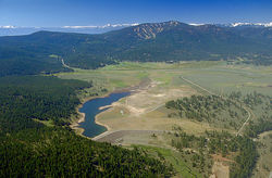
Polaris strike-slip fault
The Polaris strike-slip fault is a newly discovered earthquake fault located approximately 35 miles from Truckee, California, USA. The fault lies near the U.S. Army Corps of Engineers Martis Creek Dam. The fault was discovered using Light Detection and Ranging (LiDAR) which maps areas using laser technology. The fault is 22-miles long and is near two other faults in the area. Researchers discovered the fault after the layer of forested area was removed from the LiDAR created map. The fault was named after the Polaris Mining camp as it runs through the old mining area.
"The fault could produce an earthquake with up to a 6.5 to 6.9 magnitude, according to the study published by (Lewis) Hunter and his colleagues in the June issue of the Bulletin of Seismological Society of America. Because the fault connects to others in the area, the magnitude could be even higher if they ruptured at the same time". [1] [2]'
References
- ↑ MSNBC Technology and Science New Hidden Earthquake Fault Found in California. Retrieved on 2011-06-19.
- ↑ Bulletin of the Seismological Society of America; June 2011; v. 101; no. 3; p. 1162-1181; DOI: 10.1785/0120090261 © 2011 Seismological Society of America LiDAR-Assisted Identification of an Active Fault near Truckee, California LiDAR-Assisted Identification of an Active Fault near Truckee, California. Retrieved on 2011-06-19.
